Commune de la Chapelle-aux-Saints
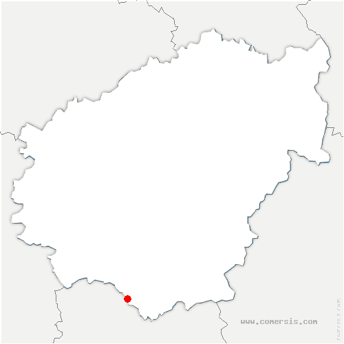
la Chapelle-aux-Saints est une commune du département de la Corrèze, dans la région de Nouvelle-Aquitaine.
Chapelle-aux-Saints fait partie du canton de Midi Corrézien 
la Chapelle-aux-Saints adhère à la la communauté de communes Midi Corrézien 
la Chapelle-aux-Saints fait partie du bassin de vie de Vayrac 
![]() Le maire de la Chapelle-aux-Saints est M. Gérard LAVASTROU, Ancien agriculteur exploitant
Le maire de la Chapelle-aux-Saints est M. Gérard LAVASTROU, Ancien agriculteur exploitant
![]() La population de la Chapelle-aux-Saints est de 260 habitants (2025)
La population de la Chapelle-aux-Saints est de 260 habitants (2025) 
![]() L'altitude moyenne de la Chapelle-aux-Saints 140 mètres.
L'altitude moyenne de la Chapelle-aux-Saints 140 mètres.
Le code postal de la Chapelle-aux-Saints est : 19120
Le code INSEE de la Chapelle-aux-Saints est : 19044
Chapelle-aux-Saints en chiffres
0 Il n'y a aucun établissement scolaire à Chapelle-aux-Saints.
17.5 La part des résidences secondaires est de 17.5 %. 
Carte de toutes les villes de la Corrèze
 Tous les chiffres et statistiques sur Chapelle-aux-Saints sur le site Insee.fr
Villes aux alentours de la Chapelle-aux-Saints
Végennes : à 1.36 km
Curemonte : à 2.34 km
Saint-Michel-de-Bannières : à 3.24 km
Branceilles : à 3.26 km
Vayrac : à 3.98 km
Queyssac-les-Vignes : à 4.10 km
Bétaille : à 4.64 km
Condat : à 4.73 km
Marcillac-la-Croze : à 5.74 km
Saint-Julien-Maumont : à 6.03 km
Chauffour-sur-Vell : à 6.08 km
Vignon-en-Quercy : à 6.12 km
Bilhac : à 6.23 km
Puy-d'Arnac : à 6.86 km
Strenquels : à 6.97 km
Nonards : à 7.12 km
Cavagnac : à 7.12 km
Saint-Bazile-de-Meyssac : à 7.28 km
Sioniac : à 7.37 km
Saint-Denis-lès-Martel : à 7.57 km
Carennac : à 7.62 km
Meyssac : à 8.64 km
Saillac : à 8.66 km
Tudeils : à 8.79 km
Beaulieu-sur-Dordogne : à 8.89 km
Lostanges : à 8.93 km
Liourdres : à 8.98 km
Astaillac : à 9.12 km
Puybrun : à 9.16 km
Pescher : à 9.52 km
Floirac : à 9.64 km
Tauriac : à 9.69 km
Altillac : à 9.72 km
Collonges-la-Rouge : à 9.81 km
Girac : à 10.31 km
Lagleygeolle : à 10.44 km
Bassignac-le-Bas : à 10.75 km
Gintrac : à 10.84 km
Martel : à 10.91 km
Ligneyrac : à 11.02 km
Sérilhac : à 11.33 km
Chenailler-Mascheix : à 11.88 km
Bretenoux : à 11.94 km
Prudhomat : à 11.96 km

 Cartographie


 Base de données